One of my favourite U.S. Coast Guard Lighthouse Keepers is Ida Lewis. This modern buoy tender was christened as a tribute to one of the great women in Coast Guard history.
 |
| Borrowed from the USCG website |
I experienced several examples of this when I was stationed in Alaska. I remained confused for at least 6 months as I tried to memorize the names and locations of various landmarks. My favourites in the state capitol were the Sub Base, the end of the road, Sheep Creek and the Ore House.
 |
| (borrowed from Urban Spoon link) |
The mines have been closed for quite some time. They were used for guided tours until there were significant safety concerns.
 |
| [borrowed from http://www.tendertale.com/tenders/103/103-3.jpg] |
The first time someone in town mentioned the Sub Base, they saw my confusion on my face before I could respond verbally. I screwed up my face, squinting and lowering my eyebrows. They explained the geographic specifics, and I asked if they were referring to the Coast Guard Station parking lot.
No was the reply, they meant the parking lot adjacent to the Sub Base warehouse. That building was abandoned and falling apart, but since subs had been stationed there in WWII, they still used the 60+ year old name for the place.
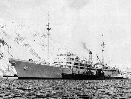
In the picture above you can see the USS Holland as she shepherded her "little chicks" from the North Atlantic to the North Pacific. The mountains in the background are "small" by Alaskan standards. Juneau and much of the towns on the Inside Passage have fjord like mountain ranges between 4-6 thousand feet. These mountains have very steep slopes from sea level up to their peaks.
 |
| The Barracuda (SS-163) in Gastineau Channel in 1933 [borrowed from this page with a wide range of photos from 1930-1940s era submarines] |
 |
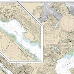
| Nautical Chart of the Juneau area Borrowed from NOAA |
This link from a Juneau tourism website will provide some great info on things to do (when it comes to trail hiking and state or national parks Juneau.
You can also see some great Juneau photos, and shots from other parts of the largest state in the U.S.
The end of the road was also puzzling. Juneau includes a small island (Douglas) and a larger chunk of the mainland. There is a road covering each of those places, with a small bridge in between. That equates to 4 ends of the road, since Juneau is landlocked. Apparently this assumption was not correct. The "end of the road" only explained the termination of the road south of the Ore House.
All the other "ends" had separate names based on other nearby landmarks.
Sheep Creek was a great fishing spot south of Juneau's downtown. I assumed that its name was related to frequent visits of sheep, but these animals are not usually interested in being so close to the pesky humans at sea level. The river was named after Sheep Mountain further into the valley.
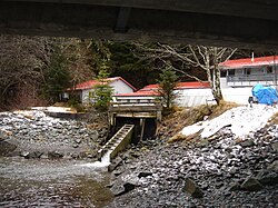
Near the hatchery above I caught my first fish on a wet fly. It was a lovely Dolly Varden with its mouth full of salmon fry.
You can also see some great Juneau photos, and shots from other parts of the largest state in the U.S.
The end of the road was also puzzling. Juneau includes a small island (Douglas) and a larger chunk of the mainland. There is a road covering each of those places, with a small bridge in between. That equates to 4 ends of the road, since Juneau is landlocked. Apparently this assumption was not correct. The "end of the road" only explained the termination of the road south of the Ore House.
All the other "ends" had separate names based on other nearby landmarks.
Sheep Creek was a great fishing spot south of Juneau's downtown. I assumed that its name was related to frequent visits of sheep, but these animals are not usually interested in being so close to the pesky humans at sea level. The river was named after Sheep Mountain further into the valley.
 |
| Sheep Creek Salmon Hatchery (borrowed from Wikipedia - Wiki link ) |
I later learned that those white spots representing some land mammals that I often saw up near Mount Roberts or the Mendenhall Glacier were actually mountain goats rather than Dall's sheep. The sheep do not live in the Southeast portion of Alaska (often called the pan handle). They also prefer a drier climate, which you cannot find in the Tongass National Forest. This is a temperate rain forest which makes the Southeast area of Alaska very moist and sustains the snow capped mountains throughout the year.
So before you name something, think about the hidden meaning of those words.
 |
