Monday, December 29, 2014

Historic naming of places and objects

I have always appreciated the practice of naming ships and places based on the history of any group.


One of my favourite U.S. Coast Guard Lighthouse Keepers is Ida Lewis.  This modern buoy tender was christened as a tribute to one of the great women in Coast Guard history.

Borrowed from the USCG website
Military and law enforcement agencies are particularly fond of this method, as they are interested in preserving their heritage over long periods of time.  Longtime residents of towns also end up confusing the newcomers by using the former names that were passed down from their predecessors. Most of the structures and landmarks are still there, but they are no longer fulfilling their intended purpose.

I experienced several examples of this when I was stationed in Alaska.  I remained confused for at least 6 months as I tried to memorize the names and locations of various landmarks.  My favourites in the state capitol were the Sub Base, the end of the road, Sheep Creek and the Ore House.

(borrowed from Urban Spoon link)
The Ore House was a great place to have a work party.  The food was great, the atmosphere was rustic, and the tourists didn't get far south on the mainland.  Being a nautical person, I thought it was the Oar House and was named after a traditional location for  launching canoes or kayaks.  My friends got a lot of laughs out of that blunder, and reminded me that Juneau got on the maps drawn by non-native folks lured by gold and other resources.

The mines have been closed for quite some time.  They were used for guided tours until there were significant safety concerns. 

[borrowed from http://www.tendertale.com/tenders/103/103-3.jpg]


The first time someone in town mentioned the Sub Base, they saw my confusion on my face before I could respond verbally.  I screwed up my face, squinting and lowering my eyebrows.  They explained the geographic specifics, and I asked if they were referring to the Coast Guard Station parking lot.
No was the reply, they meant the parking lot adjacent to the Sub Base warehouse.  That building was abandoned and falling apart, but since subs had been stationed there in WWII, they still used the 60+ year old name for the place.

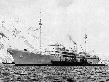
In the picture above you can see the USS Holland as she shepherded her "little chicks" from the North Atlantic to the North Pacific.  The mountains in the background are "small" by Alaskan standards.  Juneau and much of the towns on the Inside Passage have fjord like mountain ranges between 4-6 thousand feet.  These mountains have very steep slopes from sea level up to their peaks.


The Barracuda (SS-163) in Gastineau Channel in 1933
[borrowed from this page with a wide range of photos from 1930-1940s era submarines]

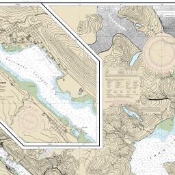
Nautical Chart of the Juneau area
Borrowed from NOAA
This link from a Juneau tourism website will provide some great info on things to do (when it comes to trail hiking and state or national parks Juneau.

You can also see some great Juneau photos, and shots from other parts of the largest state in the U.S.

The end of the road was also puzzling.  Juneau includes a small island (Douglas) and a larger chunk of the mainland.  There is a road covering each of those places, with a small bridge in between.  That equates to 4 ends of the road, since Juneau is landlocked.  Apparently this assumption was not correct.  The "end of the road" only explained the termination of the road south of the Ore House.
All the other "ends" had separate names based on other nearby landmarks.

Sheep Creek was a great fishing spot south of Juneau's downtown.  I assumed that its name was related to frequent visits of sheep, but these animals are not usually interested in being so close to the pesky humans at sea level.  The river was named after Sheep Mountain further into the valley.

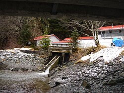
Sheep Creek Salmon Hatchery
(borrowed from Wikipedia  - Wiki link )
Near the hatchery above I caught my first fish on a wet fly.  It was a lovely Dolly Varden with its mouth full of salmon fry.


I later learned that those white spots representing some land mammals that I often saw up near Mount Roberts or the Mendenhall Glacier were actually mountain goats rather than Dall's sheep.  The sheep do not live in the Southeast portion of Alaska (often called the pan handle).  They also prefer a drier climate, which you cannot find in the Tongass National Forest.  This is a temperate rain forest which makes the Southeast area of Alaska very moist and sustains the snow capped mountains throughout the year.


So before you name something, think about the hidden meaning of those words.


Monday, May 26, 2014

Crushers versus Rippers

[All the thoughts expressed in this blog are completely my own, and most likely are not backed by scientific discovery in any possible way.]

I find it very interesting to learn about the way that some animals are more asymmetric than you would imagine.

Take humans as a first example.  Most of us have a lot of body parts of two when we are born:  two arms; two legs; two eyes; etc.   We have a few parts of one, but I think they are outnumbered by all of the pairs.  We also have some organs which have a pair or are separated into two lobes.

When we use these pairs to work, we eventually develop a dominant side.  This side is the one which allows us to make physical motions in the most efficient manner.

Many of us have watched toddlers try and catch, throw or hit a ball.  When you throw the ball in the air, after considerable repetition, most toddlers will develop a dominant side.  They catch the ball with one hand, and they may even throw it back with the same one.  If you start tossing them a ball to hit with one of those huge plastic bats, the parents may position the child in their dominant batting stance so they can guide them from behind, showing them how to swing so they will be able to hit a few balls.  If that doesn't work, they may eventually switch to the other side in an attempt to increase the likelihood that the child has more consistency in hitting the ball.

I myself am right side dominant.  I can accomplish tasks more powerfully when I approach them from a right side perspective.  I throw right handed, I usually bat right handed, I golf right handed, and my dominant leg is the right one when I play soccer.  However, I am left eye dominant in several situations such as when I bat lefty, kick with my left foot (quite useful when playing any position), and I can throw with my left hand, but without very much power.  There is as much accuracy, but not very much UMPHOOF. 

I did not do any real shooting before I joined the military, but the instructors told me pretty quickly that my left eye was the one that needed to do all the aiming.

When using the pistol I tried to follow their guidance on shutting my left eye to align the target with the sights on the gun, but I could not hit center mass.   They gave me a cardboard cylinder from a paper towel roll and had me look through the cylinder towards the target with both eyes open.  The target was rather fuzzy, but I could see it.  First they told me to close my left eye, which is quite difficult for me to do without scrunching up my face into a Popeye-like squint.  The target had disappeared, and the facial muscles in my cheek were exhausted from the efforts.  Then I repeated the process with my right eye closed, and I could see the target clearly.  Shooting with my right eye closed increased my accuracy, and was less difficult for my right cheek muscles to accomplish.  The rifle was a whole different story, as I had to shoot with my left hand, but I did qualify.

Back to the connection to the sea you all have been waiting for.  My grandparents lived on an island, and my brother and I both inherited our grandpa's love of the sea.  He started fishing as a teenager, and continued this practice for 60 more years.

When they retired, my grand parents moved to the small summer home they built on an island. Grandpa got a non commercial lobster license that allowed him to put out ten lobster pots. 

We would help him to harvest the lobsters and rebait the pots before he threw them back in the water.  When we ate our luscious dinner later that night, I wondered why the crusher claw tasted so good while the other claw was chalky and distasteful. The claw with more powerful muscles was the crusher, while the chalky one was meant for more deliberate and delicate work. 

I am not a biologist, so I don't know the full story on why these critters have such a profoundly asymmetrical development, but I do know that it results in two large claws with very different jobs (unlike its caribbean cousin).  The lobsters in the tropical climes have much larger tails, less prominent claws and giant antennae, which you can see in the link above.

I would imagine that the left eye dominant critters have the crusher on the left side when viewed from above, while the right eye dominant mud bugs display their crusher on the right. 
This photo shows a live blue lobster on top of his other North American Lobster friends.

But our northern mud bugs have different claws designed for different purposes.  The beautiful blue baby pictured above is a left hander.  You can tell this by the shorter but more bulky left claw.  This appendage is the crusher.  It has more power because it has to hold on to its prey.  The right hand claw is the ripper.  It shreds the food into edible sized pieces.

In my personal and professional relationships, I am perpetually the crusher. When you need someone to bring the hammer down, bring in the crusher.  If you need a bulldog to fix something quickly, bring in the crusher.  If you need to have a detailed analysis completed very thoroughly, the crusher is the best choice.  
If you want something done which doesn't require the wrecking ball mentality, you need the ripper. Rippers are the more delicate and deliberate partners. They work slowly and methodically. 

Wednesday, January 1, 2014

Maps, charts and turtle parts

I suppose that I have spent most of my physical life on solid ground, but my heart and mind are normally floating around somewhere near the sea.  I have been trying to organize my home office, and I have been coming across quite a few charts.  No, these are not the charts that come in graph, pie, or bar form (though I do have quite a few of those too, displayed inside books or papers), but the big paper ones filled with pencil marks, contour lines, hydrographic information and buoy characteristics.

[borrowed from wikimedia]


My husband is more connected to mountains that provide skyward contour information, but the tools used to navigate on both are similar.

[borrowed from http://www.chugachwildernesslodge.com/images/TopoMap.jpg]


You need to measure things, so that you know how far that you have traveled over a certain time period.

[borrowed from http://www.waterencyclopedia.com/images/wsci_03_img0369.jpg]

You need to be able to use a compass to identify high structures.

[borrowed from http://gruenagency.com/wp-content/uploads/2013/10/compass-old11.jpeg]


You need range information (such as maritime ranges or lining up certain mountainous or man made structures), so you man make sure that you are on the right course.

The turtle parts mentioned in the title have to do with my prefered next turtle acquisition, the beautiful map turtle.  Of course, I think it should be called the chart turtle, but you cannot win every fight, right?

[borrowed from http://www.theturtlesource.com/turtleContainer/Orange%20Miss%20map%20A(2).jpg]